Reading the Signs: Physical Indicators of an Approaching Thunderstorm
When embarking on a storm-chasing adventure, Chasing Storms and the ability to read the signs of an approaching thunderstorm from the ground is a skill that seasoned storm chasers develop over time. By recognizing these physical indicators, you can position yourself in an optimal location to witness the spectacle while prioritizing safety. Here are some key signs to look out for:
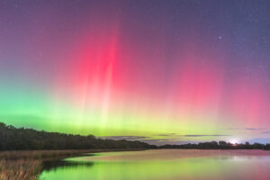
1. Changing Sky Colours:
Witnessing the transformation of the sky’s colours during an approaching thunderstorm is akin to experiencing a masterpiece painted by nature. The sky, under normal conditions, exhibits a spectrum of colours due to the scattering of sunlight by atmospheric particles. However, as a thunderstorm approaches, this canvas undergoes a captivating metamorphosis, revealing distinct alterations in its colours.
Darkening of the Sky: A Foreboding Prelude
An initial and unmistakable sign of an impending thunderstorm is the gradual darkening of the sky. The thickening cloud cover associated with the storm acts as a natural filter, obstructing sunlight. Shadows cascade over the landscape, creating an atmosphere that is dimmer, more ominous, and pregnant with anticipation. This darkening effect serves as a visual indicator, signalling the imminent presence of the storm.
Greenish Tint: Nature’s Enigmatic Touch
Adding to the allure of stormy skies is the occasional emergence of a mysterious greenish tint. This captivating coloration is often most pronounced at the leading edge of severe thunderstorms, particularly those accompanied by hail. The green hue owes its existence to the scattering of sunlight by water droplets or ice crystals within the storm clouds.
Meteorological Explanation: The Science Behind the Green Hue
The greenish tint is a result of the intricate dance between sunlight and particles of varying sizes within the clouds. Larger particles tend to scatter longer wavelengths of light, such as red and yellow, leaving the shorter wavelengths—blue and green—to dominate the scattered light. This collective interaction crafts the distinct green hue that captivates the observers below.
2. Building Cumulus Clouds: Nature’s Towering Harbingers
As the atmosphere gears up for the orchestration of a thunderstorm, the stage is set with the emergence of building cumulus clouds. These towering formations paint the sky with a dynamic canvas, marking the beginning of a meteorological spectacle. The evolution of cumulus clouds during this phase is a compelling visual narrative, offering insights into the potential intensity of the approaching storm.
Towering Giants: The Birth of Cumulus Clouds
As a thunderstorm takes shape, the first act unfolds with the appearance of cumulus clouds. Initially small and fluffy, these clouds signal the beginning of convective activity in the atmosphere. Warm air near the surface rises, and as it ascends, it cools and condenses into these distinctive cloud formations.
Rapid Ascension: A Symphony of Growth
What follows is a mesmerizing display of rapid vertical growth. Cumulus clouds can ascend with remarkable speed, reaching impressive heights within a short span. This vertical development is a testament to the vigour of the updrafts within the storm. The towering stature of these clouds becomes a visual barometer, indicating the atmospheric forces at play.
Indicators of Updrafts: Unveiling the Storm’s Dynamics
The vertical growth of cumulus clouds is a reliable indicator of strong updrafts within the storm. Updrafts play a pivotal role in the development and intensification of thunderstorms. As warm, moist air rises, it condenses into these billowing formations. The more robust the updrafts, the higher and more imposing the cumulus clouds become.
Key Ingredient for Thunderstorm Development: Updrafts Unleashed
In the theatre of thunderstorm development, strong updrafts are a central character. They signify the storm’s ability to draw energy and moisture from the surface, essential for the birth and sustenance of a thunderstorm. Cumulus clouds reaching impressive heights are emblematic of the atmospheric conditions conducive to the storm’s maturation.
Nature’s Canvas Unfolding: A Visual Prelude
The spectacle of building cumulus clouds is not just a meteorological phenomenon but also a visual prelude to the impending drama in the sky. Observing the speed and grandeur of their ascent provides storm chasers and weather enthusiasts with cues about the storm’s potential strength and the intensity of the atmospheric convection underway.
Photographic Opportunities: Capturing the Drama in the Skies
For the storm chaser armed with a camera, this phase presents unparalleled photographic opportunities. The dynamic interplay of light and shadow on the towering cumulus clouds creates breath-taking images that encapsulate the raw power and beauty of nature in the throes of a thunderstorm’s birth.
As you witness the ascent of these majestic cumulus clouds, you’re not just observing a meteorological process; you’re partaking in the unfolding drama of nature’s symphony in the sky.
3. Anvil Cloud Formation: A Crown for the Mighty Thunderstorm
In the grand theatre of thunderstorm evolution, the emergence of an anvil-shaped cloud stands as a distinctive and awe-inspiring feature, symbolizing the maturity and strength of the storm. This celestial crown, perched atop the storm, unveils a significant chapter in the life of a thunderstorm and serves as a visual beacon for storm chasers seeking out powerful and potentially severe weather.
Anvil Cloud Unveiled: A Mark of Maturity
As a thunderstorm progresses through its life cycle, the development of an anvil cloud marks a crucial stage. This expansive, flat cloud formation spreads horizontally at the top of the storm, resembling the shape of an anvil. The anvil is born as the storm reaches the upper troposphere, encountering stable air that halts its vertical ascent.
Encounter with Stability: Sculpting the Anvil
The anvil cloud takes shape when the thunderstorm’s vigorous updrafts encounter a layer of stable air in the upper atmosphere. This encounter arrests the vertical growth of the storm, forcing it to spread horizontally. The result is a vast, anvil-shaped expanse of cloud cover that can extend for great distances downwind of the storm’s core.
Identification of Power: A Visual Yardstick
Spotting an anvil cloud is a visual testament to the power and potential severity of a thunderstorm. The expansive nature of the anvil indicates a robust and well-organized storm system. As the storm ascends into the upper troposphere, it taps into atmospheric dynamics that can fuel severe weather phenomena such as large hail, damaging winds, and even tornadoes.
Meteorological Significance: Insights into Storm Intensity
Meteorologically, the presence of an anvil cloud signifies that the thunderstorm has reached the equilibrium level in the atmosphere. This equilibrium, where the updrafts and surrounding air currents balance, contributes to the distinctive shape of the anvil. Understanding this meteorological indicator allows storm chasers and meteorologists to gauge the storm’s intensity and potential for severe weather.
4. Increasing Wind: Nature’s Prelude to Thunderous Reverie
As the atmosphere prepares to unleash the symphony of a thunderstorm, one of the early musicians to join the ensemble is the wind. Before the storm takes centre stage, an increasing wind becomes a noticeable overture, setting the tone for the impending meteorological performance. This rise in wind speed is not merely a breeze; it’s a prelude to the atmospheric drama about to unfold.
Rustling Whispers: The Wind’s Early Murmurs
Before the full orchestration of a thunderstorm, the wind begins to whisper its presence. A subtle rustling, a gentle breeze, evolves into more pronounced gusts. This preliminary stirring of the air is a precursor to the storm’s arrival, a quiet acknowledgment of the atmospheric forces gathering momentum.
Gusty Ballet: Wind in a Crescendo
As the thunderstorm approaches, the wind undergoes a transformation, engaging in a dance of increasing intensity. It picks up speed, becoming gusty and animated. The once tranquil air becomes a dynamic force, carrying the energy and anticipation of the storm to the landscape below.
Temperature’s Dance: Choreography of Atmospheric Shifts
Concurrently, the rise in wind speed is often accompanied by a subtle yet perceptible drop in temperature. The atmospheric ballet unfolds as the storm’s gust front, the leading edge of the advancing storm, displaces warmer air. This dance of temperature change is a harmonious accompaniment to the crescendo of wind, contributing to the atmospheric ballet’s overall choreography.
Pressure’s Melody: A Symphony in Atmospheric Variation
In tandem with the increasing wind and temperature fluctuations, there’s a subtle shift in atmospheric pressure. The atmospheric symphony composes a melody as the storm’s influence alters the pressure in the surrounding air. Storm chasers attuned to these atmospheric nuances can use the changing pressure as an additional cue to the storm’s proximity.
Nature’s Warning: Wind as a Harbinger of Storms
For those versed in the language of weather, an increasing wind is a clear signal of an imminent storm. Meteorologists and seasoned storm chasers recognize this wind-driven overture as a prelude to more dramatic atmospheric changes. The gusts serve as nature’s warning, urging observers to prepare for the impending tempest.
Safety and Preparedness: Responding to the Wind’s Invitation
As the wind gains momentum, storm chasers and weather enthusiasts should prioritize safety and preparedness. The gusty winds heralding the storm’s approach can be both exhilarating and potentially hazardous. Securing equipment, ensuring a stable chase position, and remaining vigilant to evolving weather conditions become paramount as the wind intensifies.
Capture the Moment: Wind in Visual Narrative
For the storm chaser equipped with cameras, capturing the dance of the wind adds depth to the visual narrative of the storm chase. Dynamic shots of trees swaying, dust being lifted, or flags fluttering in the gusts convey the kinetic energy of the approaching tempest. It is a moment to freeze in time, a visual testament to the atmospheric forces at play.
In the overture to a thunderstorm, the increasing wind serves as a herald, beckoning the audience to witness nature’s symphony. As you embark on your storm-chasing adventure, pay heed to the wind’s prelude, for it is the precursor to the thunderous reverie about to unfold in the vast expanse of the skies.

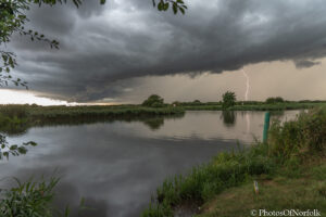
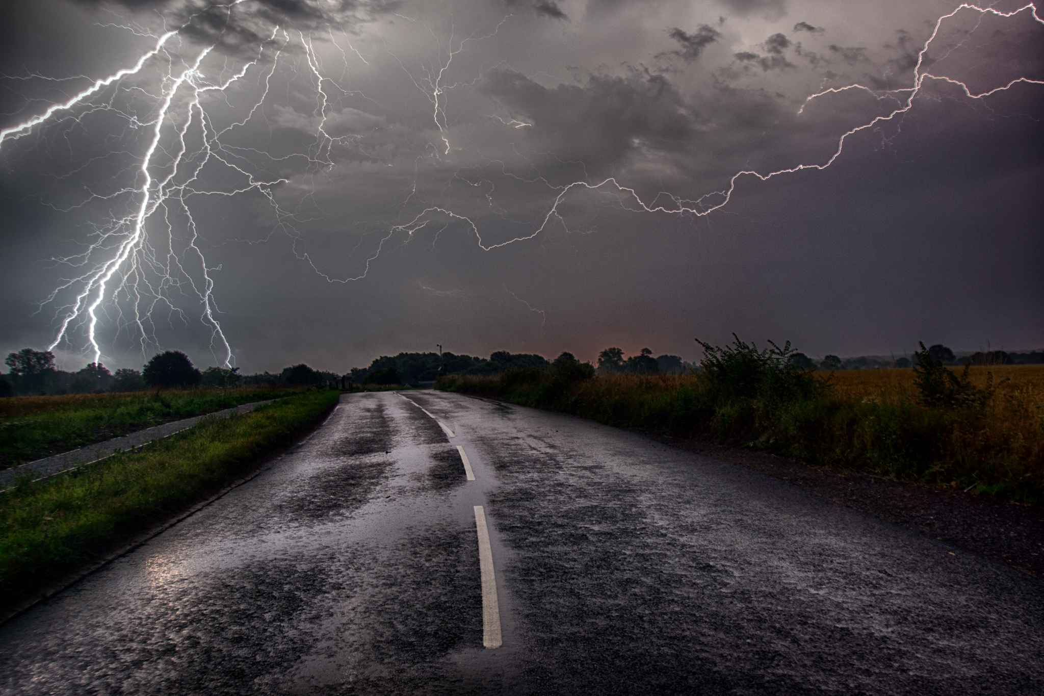
5. Distant Thunder and Lightning: Nature’s Sonic and Visual Overture
In the realm of storm chasing, the auditory and visual symphony of distant thunder and lightning serves as a profound overture to the impending meteorological drama. Nature, in its grandeur, orchestrates this symphony, providing storm chasers with essential cues and early warnings of an approaching storm. The distant rumbles and flashes become the ethereal prelude to the atmospheric crescendo about to unfold.
Echoes of Thunder: Nature’s Drumroll
Long before the storm clouds unleash their torrential downpour, distant rumbles of thunder resonate through the air. These sonic echoes, akin to a celestial drumroll, mark the commencement of the storm’s overture. The low-frequency vibrations, traveling through the atmosphere, are a primal announcement of the atmospheric turbulence that lies ahead.
Flashes of Illumination: Lightning’s Silent Strobe
In tandem with the distant thunder, the night sky or cloud-covered day is intermittently illuminated by flashes of lightning. This silent strobe of brilliance paints the atmospheric canvas with ethereal light, revealing the contours of the storm in the distance. The interplay of light and shadow sets the stage for the impending meteorological spectacle.
Early Warning System: Nature’s Alert to Storm Proximity
Distant thunder and lightning serve as an innate early warning system for storm chasers. The time lapse between the flash of lightning and the subsequent rumble of thunder provides valuable information about the storm’s proximity. Counting the seconds between the two allows for a rough estimation of the storm’s distance in miles.
Directional Awareness: Sound and Light Mapping
As a storm chaser and Tracking a Storm, it’s essential to be attuned not only to the presence of distant thunder and lightning but also to their directional cues. The sound of thunder can be influenced by atmospheric conditions, and discerning the direction from which it originates aids in gauging the storm’s movement. Simultaneously, the direction of lightning flashes provides a visual map of the storm’s location.
Electric Atmosphere: Lightning’s Silent Drama
Beyond its visual spectacle, lightning plays a vital role in storm dynamics. The electrical discharge during a thunderstorm contributes to the ionization of the atmosphere, altering its composition. Lightning, in its silent brilliance, is a testament to the immense energy within the storm, a captivating display of nature’s electric prowess.
Safety First: Responding to Nature’s Signals
While the distant sounds of thunder and flashes of lightning can be mesmerizing, they are also indicators of potential danger. Storm chasers must prioritize safety, especially as the storm draws near. Seeking shelter, monitoring weather updates, and remaining vigilant to changing conditions are crucial responses to nature’s signals.
Capture the Elemental Ballet: Photography Amidst the Storm’s Prelude
For the storm chaser equipped with a camera, capturing the elemental ballet of distant thunder and lightning adds a layer of visual storytelling to the chase. Long-exposure shots that capture the intricate dance of lightning against the backdrop of the darkened sky become timeless moments frozen in the storm’s prelude.
In the symphony of storm chasing, distant thunder and lightning are the elemental movements that announce the arrival of nature’s grand performance. As a storm chaser, attuning your senses to this sonic and visual overture allows you to not only witness but also interpret the atmospheric narrative unfolding on the vast canvas above.
6. Drop in Temperature: Nature’s Thermometric Prelude to Thunder
In the atmospheric overture to a thunderstorm, a sudden drop in temperature emerges as a climatic prelude, signalling the imminent arrival of nature’s tempest. This thermometric symphony unfolds as the storm’s outflow boundary sweeps across the landscape, orchestrating a noticeable decrease in ambient temperature. Armed with a thermometer, storm chasers can gauge this meteorological shift, enhancing their ability to anticipate the approaching atmospheric spectacle.
Thermal Ebb and Flow: The Atmospheric Ballet Begins
As the stage is set for a thunderstorm, the atmosphere undergoes a subtle dance of temperature fluctuations. In the prelude to the storm, the ambient temperature experiences an ebb and flow, reflecting the intricate interplay of warm and cool air masses vying for dominance. The thermal ballet is a precursor to the atmospheric drama about to unfold.
Sudden Chill: The Theatrical Drop in Temperature
The defining moment in this thermometric symphony is the sudden and perceptible drop in temperature. As the storm’s outflow boundary, a leading edge of cool air, advances ahead of the storm, it displaces the warmer air mass. This displacement manifests as a distinct chill in the air, a theatrical gesture heralding the storm’s imminent arrival.
Outflow Boundary Dynamics: The Conductor of Temperature Change
The outflow boundary, akin to the conductor orchestrating the ensemble, plays a pivotal role in this temperature drop. As the storm’s downdrafts force cooler air to the surface, it spreads out horizontally, creating the outflow boundary. This advancing boundary becomes the bearer of the temperature shift, acting as a front that precedes the main storm event.
Thermometer as the Maestro’s Baton: Monitoring Temperature Fluctuations
For storm chasers, a thermometer becomes the maestro’s baton, translating the atmospheric shifts into quantifiable data. Keeping a thermometer on hand allows for real-time monitoring of temperature changes. The instrument becomes a guide, helping storm chasers interpret the magnitude of the temperature drop and, by extension, the storm’s potential intensity.
Atmospheric Instability: The Prelude to Convective Energy
The drop in temperature is not just a climatic phenomenon; it is a manifestation of atmospheric instability. This instability is a key ingredient for the development of thunderstorms. The sudden cooling of the air creates an environment conducive to the upward movement of warm, moist air—the essential process that fuels the convective energy of a thunderstorm.
Safety Considerations: Responding to Thermal Signals
While the drop in temperature is a captivating aspect of storm chasing, safety should always take precedence. Storm chasers must interpret these thermal signals responsibly, recognizing that sudden atmospheric changes can be indicative of an approaching storm. Maintaining situational awareness and staying informed about the storm’s progression are essential safety measures.
Educational Insights: The Thermodynamic Language of Storms
Understanding the thermodynamic language of storms enriches the storm-chasing experience. Storm chasers can delve into the science behind temperature fluctuations, exploring the nuances of atmospheric dynamics. This educational aspect enhances their ability to decipher the meteorological cues embedded in the drop in temperature.
In the symphony of storm chasing, the drop in temperature serves as a sonorous movement, announcing the arrival of the storm’s main crescendo. As the thermometer records this atmospheric shift, storm chasers embark on a journey of anticipation, decoding the meteorological cues that precede nature’s thunderous performance.
7. Visible Rotation: Nature’s Aerial Ballet of Power and Grace
Within the tumultuous heart of more intense thunderstorms, a spectacular and potentially ominous dance unfolds—the visible rotation of clouds. This atmospheric ballet, marked by the presence of wall clouds or rotating updrafts, serves as a striking visual manifestation of the storm’s heightened organization. For storm chasers, this spectacle is both awe-inspiring and a critical signal that warrants cautious observation from a safe distance.
Choreography of Clouds: The Dance of Atmospheric Forces
As a thunderstorm intensifies, the atmosphere becomes a stage for a choreographed dance of powerful forces. In more severe instances, the clouds take on a mesmerizing rotation, reflecting the intricate interplay between updrafts and surrounding air currents. This rotational energy is a manifestation of the storm’s heightened organization and potential for severe weather.
Wall Clouds: The Pillars of Atmospheric Drama
A key actor in this aerial ballet is the wall cloud—a low, well-defined cloud formation that often exhibits signs of rotation. Wall clouds develop near the updraft region of a severe thunderstorm and are indicative of the storm’s dynamic and organized nature. The wall cloud’s proximity to the storm’s core makes it a focal point for storm chasers and meteorologists assessing tornado potential.
Rotating Updrafts: Nature’s Vertical Vortex
Rotating updrafts are another captivating feature of visible rotation. These towering columns of rotating air extend upward from the storm’s base, showcasing the vertical vortex within the thunderstorm. The rotation in the updrafts is a testament to the storm’s strength and the potential for the development of severe weather phenomena.
Indicator of Tornado Potential: Nature’s Cautionary Tale
Visible rotation in a thunderstorm, especially when accompanied by well-defined wall clouds or rotating updrafts, is a clear sign of the storm’s organization. In the context of storm chasing, this visual cue becomes a crucial indicator of tornado potential. While not all rotating storms produce tornadoes, the presence of visible rotation demands cautious observation due to the heightened risk.
Caution from a Safe Distance: The Storm Chaser’s Protocol
Storm chasers, captivated by the beauty and power of visible rotation, must adhere to a safety-first protocol. Cautious observation from a safe distance is paramount. While capturing the storm’s dynamics is a goal, it should never compromise the chaser’s safety. Maintaining situational awareness and staying informed about the storm’s movement are essential for responsible storm chasing.
Educational Insight: Understanding Atmospheric Dynamics
The observation of visible rotation provides storm chasers with an educational opportunity to delve into the complexities of atmospheric dynamics. Understanding the science behind rotating updrafts and wall clouds enhances the storm chaser’s ability to interpret the storm’s behaviour and anticipate potential developments.
Photographic Storytelling: Capturing Nature’s Ballet
For storm chasers armed with cameras, documenting the visible rotation is an opportunity to engage in photographic storytelling. Capturing the swirling clouds and dynamic updrafts adds a visual narrative to the storm-chasing experience, showcasing the raw power and beauty of nature’s atmospheric ballet.
In the high-stakes performance of storm chasing, the observation of visible rotation is a chapter marked by both fascination and caution. As storm chasers immerse themselves in the aerial ballet of rotating clouds, they become witnesses to the sublime power of nature’s atmospheric forces, always mindful of the need for safety and respect in the face of such grandeur.
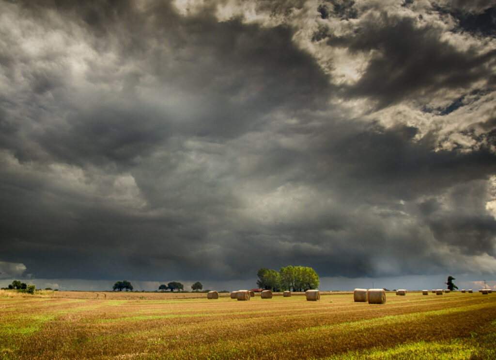
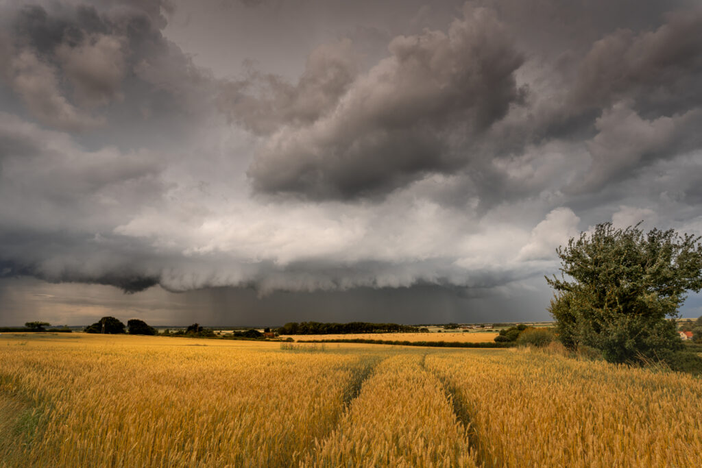
8. Ominous Cloud Features: The Sky’s Forewarning Symphony
In the orchestration of a thunderstorm, the atmosphere often unveils a visual symphony, marked by ominous cloud features that paint the sky with a dramatic palette. As a storm chaser, decoding these atmospheric compositions becomes essential. Look for the foreboding presence of shelf clouds, wall clouds, or the enigmatic roll cloud at the storm’s leading edge. These formations are not merely aesthetic; they serve as profound indicators of the storm’s intensity and dynamics, providing valuable insights into the atmospheric performance about to unfold.
Shelf Clouds: The Sky’s Advance Guard
A hallmark of approaching thunderstorms, shelf clouds present a dramatic visual display at the storm’s leading edge. These ominous, wedge-shaped formations appear as a distinct boundary between the advancing storm and the surrounding air. Shelf clouds are often associated with strong downdrafts and outflow, marking the storm’s relentless advance.
Wall Clouds: The Pillars of Storm Dynamics
Wall clouds, often found beneath a rotating updraft, are towering and well-defined cloud formations. Their ominous appearance is a direct reflection of the storm’s organization and potential for severe weather. Wall clouds serve as focal points for storm chasers, as their presence can be indicative of intense updrafts and the potential for tornado formation.
Roll Clouds: Nature’s Atmospheric Cylinder
Roll clouds are a peculiar and captivating feature of thunderstorms. These horizontal, tube-shaped clouds often appear to roll along the leading edge of a storm. While not as ominous in appearance as some other formations, roll clouds are indicative of atmospheric instability and can provide insights into the storm’s turbulent dynamics.
Indicators of Atmospheric Turbulence: Reading the Clouds
Ominous cloud features are not just aesthetic elements but windows into the storm’s atmospheric turbulence. The presence of shelf clouds, wall clouds, or roll clouds signifies dynamic interactions between updrafts and downdrafts. Observing these formations allows storm chasers to read the atmospheric script, discerning the storm’s potential for severe weather.
Storm Intensity Insights: The Language of Clouds
As a storm chaser, interpreting ominous cloud features is akin to understanding the storm’s language. The more pronounced and defined these features, the higher the likelihood of intense atmospheric dynamics. The depth of the shelf, the structure of the wall, or the persistence of the roll cloud all contribute to insights about the storm’s intensity.
Photographic Opportunities: Capturing Nature’s Drama
For the storm chaser with a camera tracking a storm, capturing the drama of ominous cloud features becomes a storytelling endeavour. Photographs of shelf clouds, wall clouds, or roll clouds against the backdrop of the storm-lit sky encapsulate the raw power and beauty of nature’s atmospheric theatre, preserving moments that convey the intensity of the storm.
In the grand canvas of storm chasing, the observation of ominous cloud features is a chapter filled with visual drama and meteorological significance. As the sky unveils its forewarning symphony, storm chasers become not just witnesses but interpreters of the atmospheric narrative, decoding the language of clouds to anticipate the storm’s intensity and potential for severe weather.
- National Weather Service (NWS):
- Storm Prediction Centre (SPC):
- The Weather Channel:
- AccuWeather:
- University Weather Departments:
- Many universities with atmospheric science programs have valuable resources and research on storm chasing. You might explore websites of universities known for meteorology studies.
- Storm Chasing Organizations:
- Organizations like the Storm Prediction Center and the American Meteorological Society often have educational materials and links to relevant resources.
- Lightning at Britannia Pier